


Marine Ways
4.61.16K Reviews
App Specs
- Version
- 1.99
- Updated On
- License
- Free
- Downloads
- 100,000+
- Developer
- Kernalite
- Categories
- Travel & Local
- Platform
- Android
Screenshots
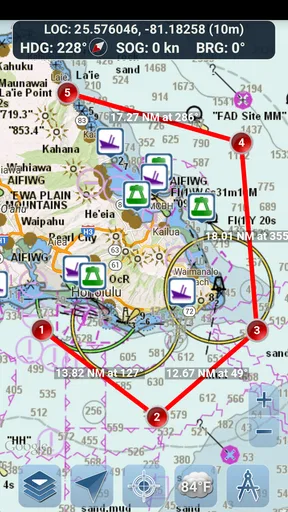
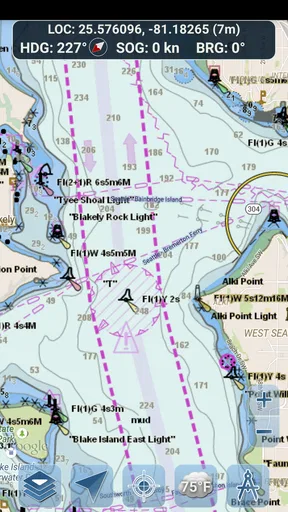
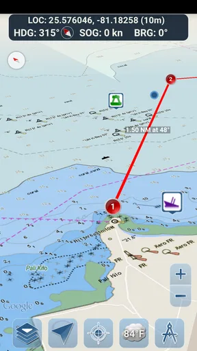
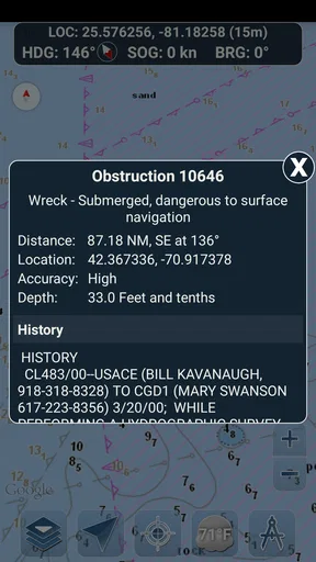
 Analysis by AppCompare
Marine Ways is the kind of travel app that makes sense only when you are close to the water. I found its appeal quickly: it brings nautical charts, route planning, and GPS-guided marine navigation into one place instead of making me jump between a general map app, a printed chart, and a separate navigation tool. It is free to start, aimed at everyone from casual boaters to people who spend more regular time on the water, and developed by Kernalite.
My first impression was practical rather than flashy. This is not an app I would open every day on land just to browse. Its value appears when I need to understand a water route, check my position while moving, or think through a trip before leaving shore. That focus is a strength, but it also explains why the app may feel unnecessary to someone who rarely travels by boat.
How Marine Ways holds up beyond the first week
I judge a navigation app’s staying power by whether it still earns a place in my routine once the novelty is gone. With Marine Ways, that means noticing which parts of trip preparation I repeat, and whether the chart-and-route workflow remains comfortable across different outings. The next section looks more closely at how readability and navigation shape that longer-term experience.
The first-week appeal comes from putting planning and navigation together
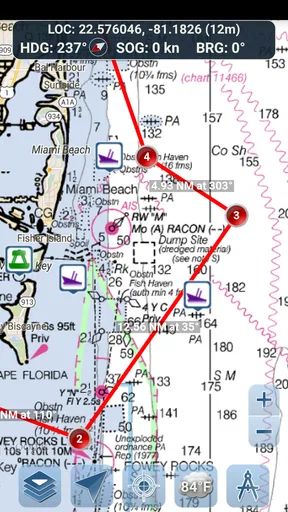
During the first few uses, the most useful change is mental: I can look at a marine chart and then move directly into route planning without treating those as two unrelated jobs. A normal road-map application is built around streets, addresses, and driving directions. Marine Ways is designed around the fact that water travel does not follow those assumptions. A route on water needs a different kind of attention, and the chart view gives the trip a more appropriate starting point.
I especially like the distinction between planning at home and navigating during the outing. Before leaving, I can think about the intended path at a calm pace. Once underway, GPS guidance gives me a way to compare my actual position with that plan. That separation is valuable because it reduces the temptation to improvise every decision while moving. It also makes the app more useful for a short local trip than a generic navigation tool that simply draws a line from one point to another.
The early learning curve is manageable for anyone already comfortable reading a map, but new boaters should not assume that a digital chart removes the need for judgment. The screen can support awareness; it cannot replace knowledge of the vessel, changing conditions, local rules, or the responsibilities of the person operating the boat. I would treat the app as a navigation aid, not as permission to travel into unfamiliar water without preparation.
One practical habit improved my first-week experience: I planned the route before I needed it. That sounds obvious, but it matters more on the water than it does on a familiar road. When I am already moving, a chart is competing with steering, observation, communication, and changing surroundings. Preparing the route in advance lets the app do its best work without turning the phone into a distraction.
Worth Reading Before You Choose

EA SPORTS FC Mobile 26 Is a Bigger Football Game, but It Takes Time

Flipboard Shows What News Apps Must Do Beyond the Feed

Switching to Android Auto Means Rethinking Your Driving Routine

Google Calendar Makes a Crowded Week Easier to Manage

Ludo King Makes the Most of the Minutes Between Plans

Baby Panda World Brings Quick Play to Modern Phones, but Its Game Library Feels Busy
Where it fits in a normal day on the water
A realistic example is a weekend outing where I want to travel from a launch point to a swimming area, a marina, or another familiar destination. I can use Marine Ways before departure to examine the route, then keep the GPS view available while traveling. If the group changes plans, I can reconsider the route rather than relying on memory alone. That makes the app useful even when the trip is recreational and not especially ambitious.
It can also help when I am the passenger responsible for navigation. In that role, I can monitor the planned path and communicate useful information to the person steering without constantly unfolding a paper chart or trying to interpret a road-focused map. The app becomes a shared reference point, although I would still keep the driver’s attention on the surroundings rather than on the screen.
Another good use is familiar-water verification. Even if I know an area reasonably well, checking the chart before departure can reveal how much of my confidence comes from habit rather than current awareness. That is one of the less obvious benefits of a navigation app: it encourages a short planning ritual before the engine starts.
On the other hand, I would skip it for a simple land journey, a city break, or a trip where I only need restaurant and hotel recommendations. Its travel category should not be confused with a general tourism companion. Marine Ways earns its place through marine navigation, not through broad destination discovery.
The month-to-month value depends on repeated boating habits
After the novelty fades, the app’s value becomes less about discovering the interface and more about whether I actually spend enough time on the water to build a routine. For a regular boater, that routine can be worthwhile: check the chart, plan the route, review the intended trip, and use GPS guidance while underway. The same sequence can support fishing trips, leisure cruises, and practical movement between waterways.
The strongest long-term feature is the connection between preparation and execution. Many navigation tools are useful only at one stage. A paper chart is excellent for broad planning but cannot show my live position. A general map app may show location well but is not built around marine chart reading. Marine Ways sits between those approaches by giving me a planning surface and a way to follow the trip.
That does not mean it replaces every alternative. Experienced boaters who already own dedicated marine electronics may prefer a larger display, specialized hardware, or a system integrated into the vessel. A phone is portable and familiar, but it is still a phone. For occasional users, though, the lower barrier can be the deciding advantage. I do not need to learn an entirely separate device before I can understand the basic workflow.
The free price also makes repeated use easier to justify. I can try the core experience without committing money at the start, then decide whether it deserves a permanent place in my travel routine. Optional purchases cost $1.99 per item, so I would pay attention to which extras I actually need rather than buying them automatically. That is a modest entry point, but the right choice still depends on how often I boat and how demanding my routes are.
Marine Ways has a 4.6 average from around 2.3 thousand ratings, and it has passed 100 thousand installs. Those figures suggest that it has found a real audience rather than being a novelty with only a handful of users. I would not treat popularity as proof that it is right for every skipper, but it does make the app easier to take seriously as an established option in its niche.
What I would check before trusting it on a longer trip
Before using the app for a route that matters, I would spend time becoming familiar with the chart presentation and the way the GPS view behaves. The worst moment to learn a navigation interface is when I am already moving and need an answer immediately. A short practice session near familiar water can show whether the screen is readable to me and whether I can interpret the route without hesitation.
I would also prepare a backup. That does not have to mean abandoning the app; it means recognizing that a phone-based tool should not be the only thing keeping me oriented. A paper chart, another navigation source, or vessel equipment can provide useful redundancy. This is especially important for longer outings, unfamiliar areas, or situations where attention and battery availability become concerns.
One useful trade-off is convenience versus concentration. Having live GPS guidance in my pocket is convenient, but it can invite too much screen checking. I get better results when I use the display to confirm a plan and maintain situational awareness, not when I stare at it continuously. The app supports navigation; it should not become the entire navigation practice.
Maintenance is light, but the responsibility is not
The maintenance burden is reasonable for an app that I use seasonally, though it is not zero. I would keep the application updated, confirm that my phone is ready before departure, and make sure my planned route is understood before leaving. The current version is 1.99, and the minimum operating system is version 10, so compatibility is something to check before relying on an older device.
Seasonal users should be especially careful. An app can sit untouched through winter and then be expected to perform perfectly on the first warm weekend. I would open it before the season begins, revisit the interface, and test my planning routine in a low-pressure setting. That small amount of maintenance is more valuable than assuming that a familiar icon automatically means a familiar workflow.
There is also a difference between maintaining the app and maintaining good navigation habits. Updating software does not update my knowledge of a waterway, and a current application does not make an old route automatically appropriate. I would still review the trip, consider local conditions, and use common sense about where and when to travel.
Because the app is free with in-app purchases, I would keep track of which optional items are part of my normal workflow. The $1.99-per-item structure is easy to understand, but small purchases can become frustrating if I discover them only when preparing for an important outing. My approach would be to test the free experience first, identify the specific gap, and pay only when that purchase has a clear recurring benefit.
The sources of fatigue appear during longer, repeated use
The first source of fatigue is the small-screen compromise. A phone is convenient to carry, but a chart can demand more visual attention than a road map. When symbols, route details, and the live position all matter, I may need to zoom or adjust the view at exactly the time when I would rather keep my attention outside the device. That is not a unique flaw in Marine Ways, but it is a real limit of using a phone for marine navigation.
The second is the possibility of false confidence. A clean route line can make a trip look simpler than it is. The app can help me organize information, but it cannot turn an inexperienced boater into an experienced one. I would be cautious about treating the planned path as a guarantee, especially when the route is unfamiliar or the outing involves other people who may assume the phone has solved every safety question.
Another potential frustration is dependence on a routine. The app works best when I plan ahead and understand what I am looking at. If I open it only after becoming uncertain, its usefulness drops because I am asking it to compensate for rushed decisions. That is why I see Marine Ways as a habit-building tool rather than an emergency button.
Long-term users may also prefer alternatives when their needs become more specialized. Dedicated marine systems can offer a more permanent display and a setup designed around the vessel. Paper charts remain valuable because they do not depend on a phone interface. General map applications may be better for the parts of a trip that happen before reaching the water. Marine Ways is strongest when the central problem is marine route planning and GPS-supported awareness, not when I need an all-purpose travel planner.
Who should keep it installed
I would recommend it to recreational boaters who want a focused way to prepare routes and follow them on the water without immediately investing in dedicated equipment. It also suits passengers who help with navigation, people returning to boating after a break, and users who prefer a phone-based starting point before deciding whether they need a more advanced setup.
I would be more cautious about recommending it as the sole navigation solution for demanding trips. Someone who regularly travels long distances, depends on specialized onboard equipment, or needs a larger and more integrated display may outgrow a phone app quickly. Likewise, a person who goes on the water only once in a while may not build enough familiarity to justify keeping another navigation tool in their routine.
The Everyone age rating makes the app broadly approachable, but that should not be mistaken for a promise that every user can safely navigate alone. Younger or inexperienced users still need responsible supervision and practical instruction. The app is accessible; the activity itself still requires judgment.
My long-term verdict
After the initial appeal wears off, Marine Ways remains useful when I connect it to a repeatable boating habit. Its lasting value is not entertainment and not constant daily engagement. It is the quiet usefulness of having a marine-focused chart and route-planning workflow ready whenever I need to prepare a trip or check my position.
I like that it occupies a clear middle ground. It is more relevant to marine travel than a standard map app, less cumbersome to begin with than dedicated equipment, and more active during a trip than a static paper chart. At the same time, that middle ground creates limits: serious users may want more specialized hardware, while occasional users may not use it often enough to develop confidence.
Kernalite has made an app that earns its space through practical repetition rather than novelty. I would install it before a boating season, practice with it on familiar water, and keep a backup navigation method available. If that sounds like the way you travel, the free entry point makes Marine Ways easy to try. If you want a complete replacement for professional marine equipment or a general travel guide, I would choose something else.
My final recommendation is straightforward: keep Marine Ways if it makes pre-trip planning and on-water orientation part of your normal routine, but do not confuse convenience with complete seamanship. That balance is what gives it recurring value without asking it to do a job it was never meant to handle.
Pros
- Clear marine weather forecasts help with trip planning.
- Useful tide and current information for coastal navigation.
- Charts and map views make nearby waterways easier to explore.
- Supports safer decisions before heading out on the water.
- Practical information for anglers
- boaters
- and beachgoers.
Cons
- Some features may require an internet connection while offshore.
- Coverage and forecast accuracy can vary by location.
- Advanced navigation tools may feel limited for professionals.
- Map details may not replace official nautical charts.
- Frequent location access can affect battery life.
FAQs for Marine Ways
What is Marine Ways, and what can I use it for?
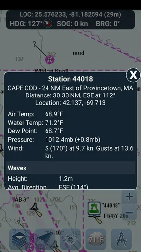
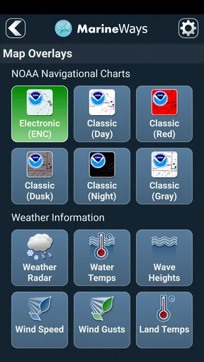
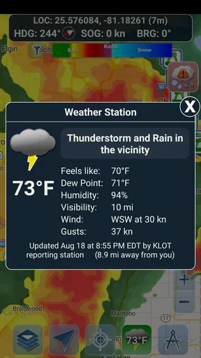
Marine Ways is a boating and marine-weather application designed to help users plan trips and monitor conditions on the water. It can provide access to weather information, forecasts, wind details, wave conditions, radar or map-based data, and other useful boating resources, depending on the available version and region. It is intended as a planning aid rather than a replacement for official marine warnings, navigation equipment, or local safety guidance.
Does Marine Ways provide accurate marine weather and forecasts?
Marine Ways can be a useful source for checking marine forecasts, wind direction, wave activity, temperature, precipitation, and changing conditions before leaving shore. However, forecast accuracy depends on the data provider, location, update frequency, and rapidly changing weather patterns. During my review, I found it most helpful for comparing conditions and preparing a route, but boaters should always verify important information through official weather services and local authorities.
Can I use Marine Ways for navigation while I am on the water?
Marine Ways may offer maps, marine locations, weather overlays, or planning tools that help users understand an area before and during a trip. Nevertheless, it should not automatically be treated as a complete marine navigation system. Mobile coverage, battery life, GPS accuracy, screen visibility, and changing chart information can affect performance. Carry appropriate nautical charts, communication equipment, and backup navigation tools whenever safety depends on reliable position information.
Does Marine Ways require an internet connection or location access?
Many of the app’s weather, map, radar, and forecast features generally require an active internet connection to download current information. Location permission may also be useful or necessary for displaying nearby conditions and relevant marine data. Availability can vary by device, operating system, and feature. Before heading offshore, users should check whether important information can be saved or accessed offline, because cellular service may be weak or unavailable on the water.
Is Marine Ways free to download, and are there in-app purchases?
The download model, included features, advertising, and premium options may differ between the Android and iOS versions and can change with future updates. Some basic marine information may be available without payment, while advanced forecasts, additional map layers, extended data, or an ad-free experience may require a subscription or in-app purchase. Review the store listing and subscription terms carefully before downloading so you understand the current costs and renewal conditions.


